

Updated on November 15, 2017 05:10 PM: Heavy rain in Kolkata returns as depression forms in Bay of Bengal
As predicted by Skymet Weather, heavy rains in Kolkata and nearby areas of West Bengal has made a come back on Wednesday. All thanks to well-marked low pressure area in west-central Bay of Bengal off the Coastal Andhra Pradesh, which has now strengthened into a depression.
Moist winds travelling from this system led to the development of convective clouds over Gangetic West Bengal including Bay of Bengal. Rain bearing clouds were hovering over Kolkata since morning hours, with rains making appearance during the afternoon hours. Rains were of moderate to heavy intensity during the initial period, which reduced slight by late afternoon but light rains are still going on.
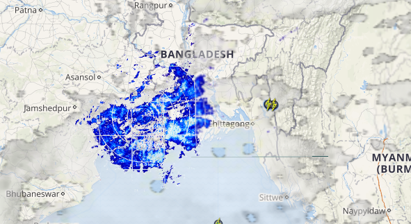
Checkout the live lightning and thunderstorm status across Kolkata
Rains may take a break for a very brief period but weathermen expect rains to pick up pace again by night. These rains will be accompanied with the strong winds gusting from 40-50 kmph. Thunderstorm and lightning are also likely over few places.
Must watch: Possible track of depression in west-central Bay of Bengal

Dumdum Observatory in Kolkata has already recorded 22 mm of rain in span of 9 hours from 8:30 am to 5:30 pm on Wednesday. Meanwhile, Alipore Observatory has received 19 mm of rain during the same duration.
As the system nears the Bengal coast, we expect rains to continue across Gangetic West Bengal for next 24 to 48 hours. Weathermen are predicting moderate to heavy rains and thundershowers during this time period.
Updated on November 15, 2017 11:10 AM: Heavy rain in Kolkata, West Bengal likely as well-marked low pressure in Bay nears
As predicted by Skymet Weather, many districts of Gangetic West Bengal including Kolkata witnessed light rainfall activity during the day. These ongoing rains have also reduced the mercury over the state, giving relief from warm and humid weather.
In the last 24 hours from 8.30 am on Tuesday, Midnapore witnessed rain to the tune of 4.6 mm, Diamond Harbour 4.4 mm, Digha 3.7 mm, Burdwan 1 mm, Bankura and Sriniketan 0.2 mm of rain. In the same span of time, Kolkata also recorded rain to the tune of 4.1 mm.
According to Skymet Weather, these rains can be attributed to the well-marked low-pressure area which is persisting over west central Bay of Bengal and adjoining North Andhra Pradesh Coast. A trough is also extending along the East Coast of the country.
The system is likely to move further in a north-northeasterly direction along the coast. In wake of this weather system nearing the West Bengal coast, the rainfall activity is likely to intensify over the coast during the next 24 hours. In fact, the intensity of showers will be moderate to heavy. These rains would be accompanied with strong gusty winds along with thunderstorm and lightning strikes.
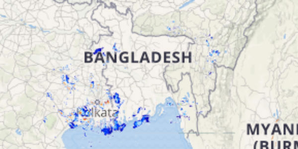
Click the image below to see the live lightning and thunderstorm across West Bengal
Districts like Kolkata, Midnapore, 24 Parganas, Murshidabad, Diamond Harbourand Nadia will see majority of the rain. As per weathermen at Skymet Weather, the interior parts of the state may also receive light to moderate rain and thundershower activity.
Not only this, these rains are also expected to hinder the first test match to be played between India and Sri Lanka from November 16 at Eden Gardens, Kolkata.
It is anticipated that good rain is likely to continue until November 16 and will decrease thereafter. The day temperatures are likely to drop significantly over the region with these ongoing rains, paving way for extremely pleasant weather conditions.
source:-skymetweather.
